GENERAL INFO
Adamello-Brenta Nature Park
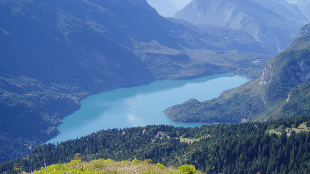
Not far from Lake Garda in the Italian province of Trentino is a Natural jewel in turquoise blue: Lake Molveno.
On its eastern side, the lake is framed by the rugged and rocky peaks of the Brenta, a mountain group of the Southern Limestone Alps, which form the UNESCO World Heritage Site while the west side with the green Plateaus of the Paganella captivates.
The area around Lake Molveno belongs to the Adamello-Brenta Nature Park and offers innumerable hiking possibilities of different degrees of difficulty and lengths.
The localities Molveno and Andalo offer many possibilities for leisure and sports activities. The village of Andalo is now even considered a sports stronghold, as a modern sports facility has recently been built there. The municipality of Andalo has about 1,000 inhabitants and lies at 1,309 m above sea level. In Andalo there is another lake of the Paganella plateau, the Andalo Lake, which appears and disappears depending on the weather conditions. The circular walk around the lake is also very popular.
The town of Molveno is particularly popular with nature lovers and culture enthusiasts. Because in addition to the beautiful nature, consisting of meadows, forests, Lake Molveno and the peaks of the Brenta Dolomites, there are also many ancient treasures to admire here, such as the Water sawmillwhich is still in operation, or the Church of San Vigilio from the 13th century.
Lake Molveno
Lake Molveno is the second largest and deepest lake in Trentino.
The lake is located at 822 m above sea level and is considered a one of the most beautiful lakes in Italy - so impressive is the unreal glowing colour of the water with the peaks of the Brenta Dolomites reflected in it. The eponymous town of Molveno lies directly on the lake.
The water of Lake Molveno is exceptionally clear and offers a visibility of up to 14 metres. The average depth of the lake is 47 m and the deepest point of the lake measures 124 m. In addition, the 4.5 km long and 1.5 km wide Lake Molveno is the largest natural alpine lake above a sea level of 800 m. Here you can admire a very rich marine flora as well as a remarkable wealth of freshwater fish.
The lake appears in incredibly various shades and has wonderful bathing beaches. The beauty of this lake was already praised by the poet Antonio Fogazzaro, who called it a "noble stone in an even nobler casket".
Lake Molveno was formed about 4,000 years ago by a landslide that blocked the valley, giving rise to this lake. Today the lake is surrounded by beech and fir forests.
In summer, the Molveno lake is thanks to the beautiful beach "Lido di Molveno" and the sports area with swimming pools, tennis courts, volleyball and basketball and a bowling area are very popular with tourists and residents.
In every season the lake has something special to offer and can therefore be visited all year round. However, the Months June until end of September the most beautiful. Especially in summer, on particularly hot days, Lake Molveno is a popular destination, because it's the perfect place to cool off.
Arrive
Lake Molveno is relatively easy to reach by car. Both from the north and from the south, the Brenner motorway the fastest access road.
In order to reach the lake and the surrounding villages, you can either take the motorway exit Mezzocorona or the exit Trento North use Via Mezzocorona, continue on the SS43 state road until you reach Mezzolombardo and then Fai della Paganella. Via Trento-Nord you follow the new expressway into the Val di Non (German: Nonstal).
From Riva del Garda at the north of the Garda'sees coming from Molveno, take the SS421 state road through Ponte Arche.
The route over Vezzano and Ranzowhich is suggested by many navigation systems, should be avoided, because the road from Ranzo no longer navigable is.
Local public transport
Molveno & Andalo
Molveno and Andalo can also be reached by public transport, although - as is often the case with public transport - it is a little more complicated.
Buses of Trentino Trasporti
The easiest way is to take the train to Trent (Trento) or Mezzocorona to drive. During the season there is a Bus connection between Trento/Mezzocorona and Molveno.
From the station Mezzocorona drives the Bus B611 and requires approx. 50 minutes all the way to Molveno.
From Trento you usually go first in the direction of Mezzocorona and then with the bus B611 from Mezzocorona further to Molveno (approx. 1:10 driving time). Another possibility is to first go in the direction of Ponte Anche and from there continue to Molveno (approx. 1:40 driving time).
In summer the last bus leaves at 18:30.
The best thing to do is to inquire in advance with the company Trentino Trasportieither by telephone at +39 0461 821000 or via the homepage.
This is especially important if you are dependent on a wheelchair, as the Trentino Trasporti intercity buses are not all wheelchair accessible.
Campingplätze & Stellplätze
If you are travelling by motorhome, caravan or bus, you can use one of the two campsites in the region:
Pitches
- The paid campsite "Camper Stop Area Rindole" in Andalo, directly on the railway that leads up to the Cima Paganella. This place costs regularly 18 euros for 24 hours. There is also a small cozy bar here.
- On the outskirts of Molveno, in the direction of Brenta, there is another pitch. Both the centre of Molveno and the lake are within walking distance. However, the regular pitch fee is 33.5 euros per day.
Campsites
Sports activities
around Molveno and Andalo
Around Andalo and Molveno there are many opportunities for sporting activities. For example, children have a large playground at their disposal where they can have fun for hours, while adults can sail across the waters of the lake in motorboats or rowing boats. Unfortunately, there is only one rental at the lake and although you can get in easily as a pedestrian via a relatively wide jetty, it is rather awkward for wheelchair users to climb a boat. Possibly it would be possible to be carried by friends in the boat.
Instead of sailing around on the lake, there is still the possibility to hike the beauties of the lake. And there are also a few wheelchair accessible options:
Hikes
Lake walk around the entire Molveno lake
The lake walk is an almost 11 km long way, which can be leisurely covered in two and a half hours, maximum 3 hours, and is suitable for all due to the small difference in altitude. The path leads into the Forests around the lakee and offers a magnificent view of the Brenta Dolomites, which are reflected in the crystal clear water. The trail is very good and wide near Molveno, but then becomes more difficult towards the other end of the lake. a little narrower and more uneven. Now and then the state road, which also leads around the lake, is crossed. The hike should in any case be accompanied by a Traction device be tackled, as there are somewhat "steeper" sections at the back of the lake.
If you prefer the Handbike If you want to use the lake as a hiking trail, you can of course also use the state road, which is usually not so busy and is also used a lot by cyclists. However, from the state road you do not have such a beautiful view of the lake as from the walking path.
If you don't dare to do the 11 km, you can instead do the lower part of the lake directly at the village of Molveno and the Bior Lake hike around. Here, too, there is a well-developed hiking trail.
Hikes on the Pradél plateau
Hikes on the Pradél plateau are also possible. To do this, from Molveno you can take the Cable car (Cabinovia) "La Panoramica which has a low entrance and can therefore also be used with a wheelchair. Please check with the train beforehand whether a trip with a wheelchair is possible.
At the top of the mountain there are several hiking possibilities, which all with traction device should be made and have different degrees of difficulty. If you don't feel up to it, you can simply enjoy the view from the restaurant terraces at the cable car. (see sightseeing)
1. from the mountain station La Panoramica to the Rifugio La Montanara.
A somewhat challenging hike is the path from the top station of the Panoramica cable car to the Rifugio La Montanara. This trail follows the forest road that runs across the entire Pradél plateau, which is why the trail quality is quite good. Nevertheless, this route covers 150 metres in altitude over 1.2 km. In between, the path has a gradient of up to 23 %. After about 30 minutes you reach the Rifugio and can enjoy a beautiful view of the peaks of the Brenta. If you run out of breath on the way or find that the trail is too challenging, you can also stop at the pretty Malga Tovre take a break and drive back from here again. Also from here you have a great view of the surrounding mountains.
2. from the cable car along the nature trail "Il mondo di Sciury
Sciury is a squirrel and on the nature trail for children you follow the squirrel and learn a lot about the forest and its visitors. Here you can take guided walks that are specially designed for children. You can also follow the trail on your own. The 2.5 km long nature trail takes about 2 to 2 ½ hours (depending on how much you look at Sciury's adventures) and covers a difference in altitude of 100 metres.
You can get a good insight into the trail quality in the video.
Valley hike through the Val delle Seghe
For those who want to dive a little into a side valley and enjoy peace and quiet away from the hustle and bustle of Molveno's beaches, we recommend the hike through the "Val delle Seghe" to Baita Ciclamino. Also this tour should with a traction device be travelled. We suggest starting from Molveno and heading anticlockwise towards Baita. Here you first walk along the right side of the Rio Massodi and can enjoy the forest and the view of the river. Shortly after a wooden bridge you reach the Baita. Behind the Baita, turn right and go down again - this time on the other side of the valley - in the direction of Molveno. This path also leads through forest at first. Shortly before Molveno, the forest gives way to meadows and fields directly along the river and you walk directly along the edge of the river through the meadows of the local farming community until you reach the state road. There you turn left again in the direction of Molveno. This circular route is about 3.5 km long and takes about 1 hour to complete.
Who subsequently the Water sawmill If you would like to visit the river, you can also turn right at the transition from the forest to the meadows, instead of going straight ahead or left along the river. Waal Way to the water sawmill. (Attention - the path can be a bit narrow in some places, therefore the passability of the path depends on the wheelchair).
If you like, you can follow the path into the valley a little further than just to Baita Ciclamino. However, it is up to the next hut, the Rifugio Croz dell'Altissimo, with about 4 km and 500 meters of altitude relatively far and strenuous, although it is a forest road. Nevertheless, it is worthwhile to follow the path a little and turn back again, if you have had enough views into the valley and want to have people around again.
Swimming
In the Molveno lake you can also go swimming. The Water temperature fluctuates in summer between 14 °C and 21 °C. For most, this temperature - even in high summer - may be too cold.
The Lake Molveno beach is all in all 12 hectares large and there are also two sections with a total of 5 hectares where dogs can jump into the cool water.
On the main beach, the Lido di Molveno, there is also a large lawn for sunbathing, three playgrounds, tennis courts, public toilets, a mini-golf course and much more.
In addition, there is an outdoor pool with Olympic sports pool (Aquapark Molveno). Unfortunately, we have not yet been able to check whether there is a possibility to use the outdoor pool as a wheelchair user.
Sightseeing
around the Molveno lake
Of course, there are other things to admire at Lake Molveno besides sporting activities.
Ride with the Panoramica cable car to the Pradél plateau
As already mentioned under Hikes listed, you can use the La Panoramica cable car from Molveno to the Pradél plateau. Here you can find restaurants and enjoy a great view of the surrounding mountains.
Before the trip, it is worthwhile to check the opening hours or if you have special requirements regarding the wheelchair. to call the railroad.
Church of St. Vigilio from the 13th century
Also worth seeing is the church of San Vigilio. The small church dates back to the 13th century and is dedicated to Bishop Vigilio of Trento. Thanks to its artistic treasures, the building is one of the most protected cultural assets of the region. Recently, the restoration of the murals and frescoes has been completed, so that they can now be admired in all their splendour. The façade, protected by a small shingle roof, is very interesting. In the upper part there is a beautiful cycle of frescoes. A precious Romanesque portal encloses a lunette painted with frescoes representing the "Saviour, the Virgin and St. John". The interior of the church is characterized by an older Romanesque church (13th century) and a later church of Gothic style. The richly frescoed apse, the completely preserved walls and the magnificent fresco on the north wall are remarkable. It depicts the "Last Supper". The altar is painted with geometric frescoes. The church of San Vigilio can only be visited during the summer months. Outside the season, visits are by appointment only. More information is available at the town hall.
Water sawmill in Molveno
The "Taialacqua" water sawmill is one of the cultural treasures of Molveno and is still in operation. The sawmill is powered, as it always has been, by the water of the Rio dei Molini. The axle of the water wheel actuates a connecting rod which transforms the circular movement into the vertical movement of the saw blade. Boards with a thickness of 6 to 10 mm were produced, the so-called "Molvene", which were marketed in the area of Riva del Garda.
At the suggestion of the priest of the time, Don Taialacqua, the Taialacqua was built around 1500 by a cooperative of the villagers. The clergyman wanted to improve the economic conditions of the population.
Later, other sawmills were built on the "Rio Molini", a fork of the Masso stream. These no longer exist today. The valley where the sawmills were built stretches from the "Ischia" plain up to the centre of the Brenta Dolomites: It is still called "Val delle Seghe". Here you can also find the Baita Ciclamino (see hikes). Outside the sawmill, a visitor centre has been set up to provide detailed information on the operation of the sawmill and the timber industry in Trentino. The impressive sawmill can be visited from mid-June to mid-September.
Outlook
The cities of South Tyrol
The next article is about the cities of South Tyrol - which ones should you know and what is there to discover there?